photo sharing and upload picture albums photo forums search pictures popular photos photography help login
bm | all galleries >> Mountains - Korea >> Soraksan (Mt.Sorak) National Park 설악산 - Korea > Soraksan National Park Panorama
previous | next

Soraksan National Park Panorama

South Korea

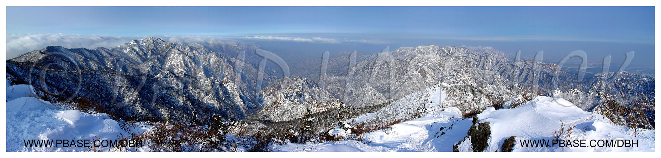
View looking North from Sochongbong Peak.

Soraksan National Park is located about 160KM northeast from Seoul. The park lies on the east
coast near the coastal city of Sokcho. Sokcho is located just off the right side of the frame.
On a clear day, the East Sea (Sea of Japan), and the DMZ to the north are easily seen.

The highest summit (Taechongbong-located behind the camera) is at 1709 meters eleavation.
Even without deep snow and having long summer daylight, the round-trip 24KM hike is very
challenging. It is best to stay overnight at the summit shelter.


other sizes: small medium large original auto
cheveux gras19-May-2015 06:36
Super Galleries, great work.Thanks for sharing them.
Guest 11-Oct-2010 10:14
It's really beautiful!!!!!!!!!!
Guest 06-Sep-2008 03:35
very beautifull view......I will go there if some one give me more money...heheheheh
FrJaro 24-Aug-2008 13:42
Hi, please help me - how to get to Sorok San from Soul? Please help me as fast as possible....
Ed 22-May-2006 05:54
What can you say about the "shelters" and the "villa" near Taechongbong? What are they like? Do you have to make reservations? What do you think they will be like in mid-July?
bm16-Feb-2004 06:10
You just got your drivers license? But you were driving in 1992!
^-^/
http://www.pbase.com/image/23822324/original
Guest 16-Feb-2004 04:14
did you go tehre by yourself ??:o


eh.. though i just got my driver license not long ago-.- i cant drive a car there i am sure!
-_____-

i want to go there

:o ahh looks so nice and cold
bm13-Feb-2004 08:06
Hina, I put more info for you under the photo! ^-^/
I drive my Jeep 4x4 there, but not to the top! Sorry, there are no roads to the top of this mountain! The 12KM hiking trail from Sorak Valley begins at about 200 meters elevation in the flat valley seen at the right side of the photo. The highest summit (Taechongbong-located behind the camera) is at 1709 meters eleavation
Guest 11-Feb-2004 04:52
how did u go there? how to go there?
where is it
Type your message and click Add Comment
It is best to login or register first but you may post as a guest.
Enter an optional name and contact email address. Name
Name Email
help private comment