


|
|
|
|
|
|
| |
First of a series...
When I first drove California State Highway 101 between San Francisco and the California North Coast, in 1970 - it was a real adventure. The highway was almost entirely two-lane blacktop, much of it steep, winding, and narrow. Logging trucks with massive loads would ride up to your car's rear bumper - no matter how fast you were traveling.
Today - high speed four lane freeway has replaced all but a few sections of the old and winding road. We trade efficiency and safety for a sense of connection to an amazing landscape. We now whiz by our landscapes in a blur.
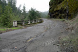
I return here - to one of my favorite sections of the old road. It sits - almost literally in the middle of nowhere - about 5 miles (8 km) south of Piercy, California - where Bridge's Creek enters the south fork of the Eel River. The roadbed has been closed for more than two decades. The new section allows one to safely pass at 55 miles-per-hour. Unless you know what you are looking for - it is unlikely that you would notice the viaduct that held this spectacular piece of road to the mountain. A fantastic feat of highway engineering.
Just below the photo is a link which reads: 'View Map'. Click on it and you will see where this section of road is located (be sure to click on the 'Satellite View' while there.You can clearly see the old roadbed winding around this mountain)
Copyright © by Stephen Phillips Photography. Please respect these rights. Do not copy or use without permission.