


|
|
|
|
|
|
| |
| 18 December 2005 | SRW |
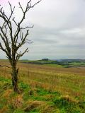
The Ordnance Survey map shows a "tumulus" on top of Buxbury Hill (centre, in the background);
and it seems fairly obvious -- along with the "long barrow" close by -- that these are all related
(...and probably to Chiselbury Fort, as well).
Please view 'original' size...
© 2000-2025 by SRW
Thank you for visiting...!
| comment |