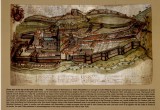
Annotated Painting of Malmesbury as it looked in 1646 during the English Civil War. Artist Unknown.
This painting of Malmesbury has features in common with the depiction of the town in Hobbes's frontispiece for Leviathan (Figure 2). Both towns are located on a high bluff. Both are surrounded by a river. Both have a double tiered wall (with fortress flags). Both have an abbey with attached houses leading to the wall.
The location of the town on a high hill is indicated by the fact that the houses outside the city wall are much smaller than those inside, indicating they are farther below us vertically even though they are in the foreground. That hilltop location is also emphasized in the writing on the upper left-hand portion of the painting (transcribed beneath it). The town is “Renowned for its natural streinth Seated on a step hill, unclimable by reason of the manie Rockes.”
The painting, according to town documentation, depicts the northeast corner of the town as it appears when one stands in the west (or southwest) and looks east (or northeast). The frontispiece of Hobbes’s Leviathan may be a view of Malmesbury from the opposite compass point: the viewer stands in the northeast looking southwest.