


|
|
|
|
|
|
| |
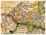
Detail van "Leodiensis Dioecesis Typus" - kaart uit de 'Atlas Minor' van ca. 1606 van Mercator/Hondius.
Noord is links, Oost is boven.
In het midden is Nieuwstadt te zien (Nieustat).
Deze kaart ging op een internetveiling net aan mijn neus voorbij.
all pictures © Henk Bril, henkbril@gmail.com
| nederlanduardo | 20-Mar-2010 01:18 | |