位于台北县万里乡的野柳地质公园为台湾北部著名的地质公园。
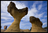
万里乡为突出于北海岸的狭长海岬,经千百万年的侵蚀、风化的交互作用,逐渐形成蕈状石、烛台石、姜石、壶穴、棋盘石、海蚀洞等地质奇观,让全长1700米的海岬,成为台湾最负盛名的地质公园。再加上周围丰富的海洋生态、渔村风情等多元地貌,让野柳成为深具教育、观光与游憩功能的著名旅游景点。野柳,还是候鸟们南迁到达台湾的第一站,也是北返时最后一个可以歇脚的地点之一。每年南迁北返之际,尤其是3月、4月与10月,是观赏过境鸟类不可错过的地点。其中又以白眉巫、黄喉巫、戴胜、授带鸟、黄眉柳莺、乌灰鹤、黑鸫等稀有鸟类更为人们津津乐道。野柳为大屯山余脉伸出海中的岬角,因大海波浪的常年侵蚀、岩石风化及地壳运动等作用造就了野柳各种奇特景观。
Yehliu (野柳) is a cape on the north coast of Taiwan in the town of Wanli between Taipei and Keelung.
The cape, known by geologists as the Yehliu Promontory, forms part of the Taliao Miocene Formation. It stretches approximately 1,700 meters into the ocean and was formed as geological forces pushed Datun Mountain (大屯山) out of the sea.[1]
A distinctive feature of the cape is the hoodoo stones that dot its surface. These shapes can be viewed at the Yeliu Geopark operated by the North Coast and Guanyinshan National Scenic Area Administration. A number of rock formations have been given imaginative names based on their shapes. The most well-known is the "The Queen's Head" (女王頭), an iconic image in Taiwan and an unofficial emblem for the town of Wanli. Other formations include "The Fairy Shoe", "The Bee Hive", "The Ginger Rocks" and "The Sea Candles."