


|
|
|
|
|
|
| Thomas on Islands | profile | all galleries >> ==Hawaii Albums== >> Ka'awaloa Trail | tree view | thumbnails | slideshow |
|
Ka'awaloa Trail to Captn Cook Monument, June 8, 2016
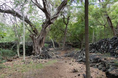
The path leads into Kealakekua Bay Park. Begin of the trail is at Napo'opo'o Road. Considering the language of these warnings my wife was worried about the venture, but in the aftermath I perceived this hike as "moderate" only. I drank 2 liters of water. Photography stops included: time to descent to the beach 1 hour 5 minutes, and same to return. As you can see from these images, the trail itself is very unremarkable, at least in the beginning. But the destination is so attractive to numerous history buffs from around the globe, that I heard German, French, Italian, Brazilian Portuguese and a Slavic language. 8 distance markers help you get oriented in the progress, albeit my impression was that they are not equally spread. Marker 2 seem to be missing. Trail is relatively flat all the way to marker 4. Descent starts between markers 4 and 5, and leads all the time away from the monument. At marker 6 the trail finally turns by 180 degree, and descent leads toward the bay where the monument is. Marker 8 is where the trail reaches the shore line. It is still a good 100m from there to the monument. At the monument I was informed that Captain Cook actually died at the shoreline where the marker 8 stands. |
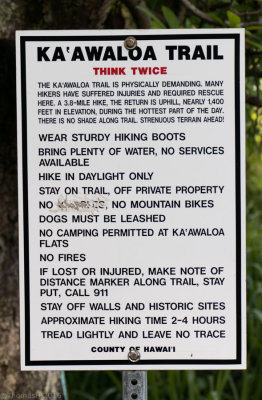 P0876 Think Twice! |
 P0879 |
 P0881 |
 P0884 |
 P0885 Marker 1 |
 P0887 |
 P0889 The "obligatory" No Trespassing signs |
 P0892 |
 P0894 Marker 3 |
 P0897 Marker 4 |
 P0900 |
 P0905 Patches of Lava |
 P0911 Marker 5 |
 P0914 Per Captain Zodiac to Captain Cook |
 P0915 |
 P0916 |
 P0922 Camping on a Black Lava |
 P0923 Marker 6 |
 P0924 |
 P0929 |
 P0937 Orange marker at a fork |
 P0938 Marker 7 |
 P0940 Shoreline appears |
 P0942 Marker 8 |
 P0944 |
 P0947 |
 P0951 |
 P0952 The Monument emerges |
 P0956 |
 P0958 Captain Cook Monument |
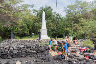 P0961 Captain Cook Monument |
 Captain Cook Monument |
 P0964 Captain Cook Monument |
 P0966 Captain Cook Monument |
 P0967 Captain Cook Monument |
 P0968 Captain Cook Monument |
 P0969 Captain Cook Monument |
 P0970 Captain Cook Monument |
 P0971 Captain Cook Monument |
 P0974 Captain Cook Monument |
 P0976 Captain Cook Monument |
 P0978 |
 P0980 |
 P0982 |
 P0987 Across the Bay |
 P0989 Heading back |
 P0992 Place of Death |
 P0991 Place of Death |
 P0993 Place of Death |
 P0997 Place of Death |
 P1002 Marker 7, begin of climb |
 P1003 Turn Right! |
| comment | share |