


|
|
|
|
|
|
| |
| 16-Apr-2015 | |
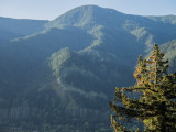
That is Starvation Ridge in the lower left hand quadrant of the image, showing the high voltage power lines crossing the ridge. The power lines receive their power from Bonneville Dam downstream. I've climbed Mt. Defiance several times up Starvation Ridge. Mt. Defiance is the highest peak in the Columbia Gorge, just short of 5,000 feet, and it's base is on the Columbia River, which is at about 100 feet above sea level at this point. The climb up Starvation Ridge is even steeper than the Mt. Defiance Trail, but it is more scenic. The 5,000 foot climb is way beyond my capabilities now, and it's probably been 20 years since I even thought of climbing Mt. Defiance.
Copyright (C) Frank Paris 2014