


|
|
|
|
|
|
| |
| 05-Apr-2015 | |
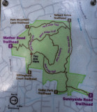
Reference map of where I hiked today. I hiked almost the whole length of most of these trails. Hike started at Mather Road Trailhead to right on Park Loop Trail to right on Cedar Park Trail to Cedar Park Trailhead. Turned around and hiked to right on Park Loop Trail past left junction to north side West Ridge. Continued on Park loop Trail to left on south trailhead to West Ridge Trail. Walk a couple hundred feet on West Ridge Trail and bushwhacked about 100 feet to a fallen log and sat there for a break and lunch. Return to West Ridge Trail and continue to right onto Summit Trail. Hike to summit and then down to right on Park Loop Trail back to left on Mather Road Trail to car. The only section of the Park Loop Trail I missed was the section from the west end of the Park Loop Trail to the return trail, the Mather Road Trailhead. That is a very short and totally boring section.
Copyright (C) Frank Paris 2014