ecoRidge
|
all galleries
>>
Artful Maps
>>
Maps Organized By Geographical Region
>>
Florida Maps
> Bay Bird
previous
|
next
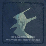
Bay Bird
Shaded relief data, topologic maps, and land cover classification of Tampa Bay and immediate area.
Sizes
8x8" Photo Paper Print Unmatted $50.00 USD
12x12" Photo Paper Print Unmatted $80.00 USD
8x8" Canvas Gallery Wrap $115.00 USD
12x12" Canvas Gallery Wrap $210.00 USD
20x20" Canvas Gallery Wrap $495.00 USD
30x30" Canvas Gallery Wrap $875.00 USD
40x40" Canvas Gallery Wrap $1595.00 USD
8x8" Canvas Float Frame $150.00 USD
12x12" Canvas Float Frame $275.00 USD
20x20" Canvas Float Frame $595.00 USD
30x30" Canvas Float Frame $1075.00 USD
40x40" Canvas Float Frame $1995.00 USD
full exif
other sizes:
small
medium
original
auto
previous
|
next
share
Type your message and click Add Comment
It is best to
login
or
register
first but you may post as a guest.
Enter an optional name and contact email address.
Name
Name
Email
help
private comment
Type your message and click Add Comment
It is best to
login
or
register
first but you may post as a guest.
Enter an optional name and contact email address.
Name
Name
Email
help
private comment