


|
|
|
|
|
|
| |
| 25.06.2008 | ® Erik Aaseth |
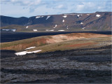
A low ridge of red rocks survived the latest eruptions at Krafla, which erupted 9 times between 1975-1984. The ridge is surrounded by new black lava all around.
Here seen westward from the small crater Liti-Leirhnj·kur, across the vast black lava-flats Leirhnj·kshraun ("hraun" means lava in Icelandic).
In the background the southern part of the mountain Gµsafj÷ll/882m.
The Krafla area is a huge caldera about 10 km in diameter, in the M²vatn region on the northern part of Iceland. Its highest peak is the Krafla volcano, 827 m high.
It resides along a 90 km long fissure zone, which supposedly has erupted 29 times and goes down to approx. 2km depth in the earth's crust.
The fissure zone is again a part of the northern tectonical rip zone (NRZ), which again connects to the eastern rip zone (ERZ) under the Vatnaj÷kull glacier,
and together they form a huge crack crossing the whole Icelandic mainland.
Copyright :® Any picture usage must be permitted in writing by Erik Aaseth.