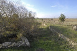
View from the water cave of Troia/Wilusa-Kask to surrounding country
Between 1997-2001, in the southwestern part of the Lower City, an artificial cave with three water-bearing arms was excavated. The cave is about 160 metres in length and parts of the corridors were cut from the rock in the third millennium BCE. The sinter (calcium deposit) was dated by the “Uran-Thorium method). At the time of Troia VI/VIIa (second millennium) the cave had already been in existence for about 1000 years and it was interpreted as “corridor/path under the earth” and by this referred to as the god “Kaskalkur”. This god who was associated with water, was mentioned in a treaty between the Hittite King Muwatalli II and King Alaksandu of Wilusa (=(W)Ilios = Ilion/Troia) as a god of the oath on the part of Wilusa.
We therefore might know of another city god of Wilusa in addition to Apaliuna (Apollo?). The corridor system runs in an eastward direction in the bedrock and contains four vertical shafts, up to 17 m. in height, that connect to the surface.
The inset in the enclosure wall of the cave marks the dimensions of the prehistoric opening, from which a channel leads into several rock-cut basins. The later Roman enlargement of the entrance in the second-third century CE used terracotta pipes to channel water into fish tanks in front of the cave. In the Byzantine period (12-13 CE) a stone-lined channel led water to a small garden.