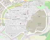
It is not my habit to use "open source" material from others, but this map, from OpenStreetMap contributors, is too important to neglect. I found it searching Wikipedia at "Fortifications of Diyarbakır". It shows how a large part of the old town was "leveled in 2015–2016 during the Kurdish–Turkish conflict." I refer in many captions to this loss, wanting to see what resulted was an important reason to return in 2024.
A UNESCO report from 2024 says (The report provides information on the measures implemented by the State Party): "No large-scale demolitions were undertaken in the Suriçi district in the buffer zone. Security incidents in 2015-16 led to destruction, after which government institutions initiated rehabilitation. Details of expropriation and negotiation processes with the right holders are provided; The Diyarbakır (Suriçi) Conservation Development Plan is legally binding and reverting to earlier versions of the plan is not legally possible."