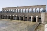
On the picture: The ‘Regülatör’ (irrigation regulator) at the mouth of the river, that separates the old town from the new center. Next to this ‘Regülatör’ lies the old ‘Taş Köprü’ (= Stone Bridge), which is now for pedestrians only, since a new double bridge for motorized traffic was opened.
Lake Beyşehir (Turkish: Beyşehir Gölü) is a large freshwater lake, situated at an altitude of c. 1120 m. It is 45 km long and 20 km wide (650-700 km²). The maximum depth is 10 metres. The water level in the lake often fluctuates by year and by season. The Sultan mountains and streams and creeks from the Anamas mountains feed the lake, while precipitation also contributes to its level. Lake Beyşehir is used for irrigation, although it is also a national park. It still offers a living to some fishermen too; next to the lake’s shores, a few restaurants in Beyşehir Town serve delicious fish dishes – the best season seems to be spring.
Correspondent: J.M.Criel, Antwerpen.
Source: Wikipedia & Personal visits (1987 -1992 - 1995).