photo sharing and upload picture albums photo forums search pictures popular photos photography help login
Don Boyd | all galleries >> Memories of Old Hialeah, Old Miami and Old South Florida Photo Galleries - largest non-Facebook collection on the internet >> Memories of Old HIALEAH, Florida - Historical Photo Galleries and Commentaries - click on image to view and read >> My old PALM SPRINGS neighborhood - Old and Current Photos Gallery > Early 2007 - aerial east to west view of West 9th Lane area of Palm Springs, Hialeah
previous | next
Early 2007 İMicrosoft & Pictometry Int'l

Early 2007 - aerial east to west view of West 9th Lane area of Palm Springs, Hialeah

Palm Springs section of Hialeah, Florida


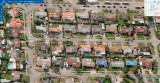
This image must have been taken in early 2007 because of the tarps still visible on some roofs after Hurricane Wilma hit us in October 2006. The view is looking west and I've added the house numbers to the roofs. The western portion of the unincorporated section of Hialeah with the Dade County street numbers and addresses is at the bottom middle and right of the photo.

W. 56th Place has been renamed to W. 56th Street. On the north side of the street it was NW 110th Street in Dade County. W. 9th Court was Hialeah on the west side, and NW 63rd Court on the east side. I used to give directions to lost drivers all the time and sometimes got a dime or a quarter for my help, or a dollar if I led them on my bike to where they were going. It is still unincorporated Dade County.

I am amazed at the number of pools that have been added to the backyards, and some residences have been expanded so much that there is little back yard left. However, the residences in this photo, except for some lushly landscaped properties, look very barren and mostly treeless with little tree canopy for a neighborhood of this age (50 years old in 2007). A lot of trees have been lost over the years, due to hurricanes, palm blight (lethal yellowing), the state cutting down tens of thousands of citrus trees to stop the spread of canker, and the newer residents removing them because they like to pay considerably more on their electric bills by having their homes fully exposed to the sun instead of being shaded.


other sizes: small medium large original auto
comment | share
Don Boyd04-Apr-2008 02:17
The unincorporated area ran from Red Road (NW 57 Avenue/W. 4 Avenue) to NW 63rd Court (W. 9th Court on the other side) on the west, from NW 110th Street (W. 56th Place on the other side) to NW 114th Street (W. 60th Street), plus an area north of NW 114th Street between Red Road and about W. 6th Avenue in a weird shape east of Lake Tahoe.

I understand that it was built first, before the rest of Palm Springs, and the residents voted against being annexed by Hialeah because the unincorporated taxes were lower than Hialeah's taxes. They are totally surrounded by Hialeah and Hialeah street numbers and for quite a while they had to rely on the county sheriff's department and fire department in emergencies until some agreement was finally reached where Hialeah police and fire would respond and Hialeah would bill the county for the services extended. The county provided garbage service back then - they probably still do. It's one of the strangest things I've ever seen in regards to municipal borders and people there must go through hell giving directions to people.

Another odd thing regarding Hialeah street/avenue numbers: in most of Hialeah (that portion north of NW 54th Street) you can determine the Hialeah street number by subtracting 54 from the Dade street number - such as 110th Street minus 54 equals 56 which is the street number in Hialeah, 103rd Street minus 54 equals 49th Street in Hialeah. You can't do anything similar with avenues - they aren't even spaced the same. NW 57th Avenue is W. 4th Avenue in Hialeah. NW 67th Avenue is W. 12th Avenue in Hialeah. That's a 10-block difference in Dade County (57th to 67th) but only an 8-block difference in Hialeah. Same with NW 67th Avenue (W. 12th Avenue) to NW 77th Avenue (W. 20th Avenue) - 10 blocks in Dade versus 8 blocks in Hialeah.

Don
Ray 04-Apr-2008 00:45
What's the history on that unincorporated area? Seems like when Hialeah was incorporated that area would have been totally empty. Did some land owner not want to be in the city? Or did they leave the city later?

It reminds me of 'little gables' near LeJune and SW 8th. Or a little strip that comes up from Sunset Dr. in Coral Gables just so one house wasn't in the city. Someone REALLY didn't want to live in the Gables way back when.

I knew another 2-way radio guy back in the 1970s, who lived in the Hialeah Un-Inc area, Dean Hoops I think. He was in the same radio club I was in.