


|
|
|
|
|
|
| |
| 1930's | Courtesy of Alvin Lederer |
Thank you to Alvin Lederer for contributing the large high resolution image that I cropped the above image from.
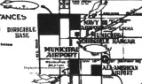
What is interesting about this image is that All-American Airport has not been expanded yet to the west to the railroad tracks on the eastern border of Miami Municipal Airport. It has also not been expanded yet to the north up to about NW 123rd Street; the northern boundary in this image is several blocks south of NW 119th Street.
More interesting is that what is now Opa-locka Executive Airport was called Navy Airport and that the dirigible hangar is called Municipal Dirigible Hangar, even though it was located further north of Municipal Airport on land that the Navy later took over through eminent domain to form a larger Naval Air Station Miami. Naval Air Station Miami eventually became Opa-locka Airport in the early 1960's except for the portion retained for Coast Guard Air Station Miami.
Unless otherwise noted under the right bottom of the photo, all images are copyrighted by Don Boyd
| comment | |