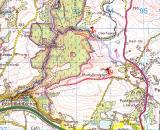
From the Bristol area, take your preferred route to the A465 ( Heads of the Valleys) road and head west, to Hirwaun. Turn north onto the A4059 for Penderyn. We approached from the north and took the first right , so you will be looking for the last left turn. If you miss it there is a cattle grid about half a mile out of the village, if you get that far; U-turn and take the first right ! THEN FIRST RIGHT AGAIN :-)
I've marked the preferred route in lilac, From the waterfall to the red pushpin where we had parked took 65 minutes, if you park somewhere near the lilac pushpin it should be about50 minutes I guess. ( The red route we took was via a bog and forest and took 2hours and 45 minutes) The going is not too bad BUT when you reach the gorge be prepared to descend the last 200 feet down quite steep steps and over some loose rocks. Take care in the village of Penderyn not to miss the "tram track" that leads up to the quarry - I did -- TWICE it is only a rough road that seems to go around the back of some cottages.
Hope all this helps, I know which way I will go in future!! If you want a phone call to clarify any of the above let me know .... Have fun , it really is a magical place. I look forward to seeing your pictures.
Cheers Derek