


|
|
|
|
|
|
| |
| 26-JUN-2010 | |
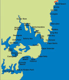
Last time we walked off the map for the "Sydney Coast 3" gallery and this new map shows where
we finished up, namely Bondi Beach. Here we see the territory ahead and our final destination which
is Bass & Flinders Point on Port Hacking. This is the southern most coastal point for the Sydney
Metropolitan Area. Our plan is to finish this project by the end of 2010. Time will tell if we succeed.
Images are subject to copyright. They may not be used without permission.