


|
|
|
|
|
|
| |
| 03-AUG-2009 | |
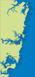
This a mud map of the entire Walking Coastal Sydney route from Barrenjoey Point in the the north
to Bass & Flinders Point in the South. As the crow flies it is a distance of 62 kms but allowing for
the need to walk around Botany Bay, Bate Bay and outer Sydney Harbour along with sundry hills, valleys,
headlands, beach foreshores and suburban street detours, the actual walking distance is more like 200 kms.
Images are subject to copyright. They may not be used without permission.