James C. Boyett, Tyler Co TX, Land Survey
Two sections, 160 acres and 80 acres, total 240 acres
Rural area located next to State Highway 69, abt. 12 miles North of Woodville, TX
Submitted by: Wanda Smith
Field notes of 80 acres R. S. Wheat Survey dated 26 Oct 1859, filed same date,
recorded Vol. C, p. 439 Surveyors Records Tyler County, TX.
Within those field notes it mentions that the Wheat Survey begins at the "NW
corner of a survey 160 acres of land made for J. C . BOYETT at a stake from
which a post oak brs. N 76 deg. W 8-2/10 vrs. and another post oak brs. N 59
deg. 15' E 2-2/10 vrs.; Thence South with the west boundary line of J. C.
BOYETT'S Survey at 433 vrs. crossed BOYETT'S Creek 5 vrs.; wide C.W. and at 940
vrs. the SW corner...(etc.)...Thence east with the South line of said BOYETT'S
Survey at 430 vrs...." (etc. and back to the beginning point of Boyett's
property line)
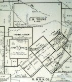
Where the 160 acres of J. C. Boyett's land is pretty much a square, the other
piece of his land, which is 80 acres, sits kind of like a diamond shape,
touching the 160 acres at one point.
Also, yesterday I was in Woodville and briefly visited the Tyler Co.
courthouse. I photographed the referred-to area from a 1965 county map showing
the two surveys with Boyett's name as well as the creek. Although the map
refers to him as "James C. Bayett" and "Boyd's Creek", the title history uses
"Boyett" exclusively. And the map shows Abstract numbers of 78 and 79 for
those properties, so they must go way back (Wheat's abstract was #687 as a
comparison).
Wanda Smith