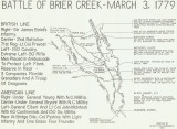
Map of the March 3, 1779 Battle of Brier Creek. Created by Clyde D. Hollingsworth, it shows the movements of Royalist and Patriot forces along the Savannah River and Brier Creek. More Photos: http://en.wikipedia.org/wiki/Battle_of_Brier_Creek
Revolutionary War Context
The Battle of Brier Creek occurred on March 3, 1779. This was only two weeks and three days following the Patriot (Whig) success at the Battle of Kettle Creek in the upper part of then extant Georgia. Unfortunately, the outcome of the battle near the confluence of Brier Creek and the Savannah River was a resounding British victory and terrible defeat for the Patriot cause.
However, and most fortunately - the British command took the wrong lesson from the battle and proceeded to pursue a strategy that took them to places & battles such as Kings Mountain, Cowpens, Guilford Courthouse, and finally - Yorktown. Both the battles of Kings Mountain and Cowpens are broadly recognized as the precipitating actions that led Lt. General Lord Charles Cornwallis to his surrender at Yorktown.
It has been suggested that the outcome of the Battle of Brier Creek was the triggering event that led to the renewed pursuit of the strategy which Lord Cornwallis was ordered to follow in his occupation and attempted subjugation of South Carolina (the "Southern Strategy"). Following the victory of Daniel Morgan over Cornwallis' light troops at Cowpens, Generals Morgan and Nathanael Greene led Cornwallis on a wild chase across North Carolina. Cornwallis' pursuit ended with his Pyrrhic victory at Guilford Courthouse. Thereafter, Cornwallis withdrew his ruined army to the coast and then positioned himself at Yorktown. The rest was, as is said - history.
Geographic and Topographic Context
Brier Creek itself is a riverine watercourse traversing much of eastern Georgia between the Ogeechee River and the Savannah River. It arises between Warrenton (in Warren County) and Thomson (in McDuffie County) in the lower portion of the Piedmont. The upper portion of the creek is surrounded by open pit kaolin mines as it passes through the Fall Line. From there it enters the upper coastal plain and courses down past towns like Wrens and Waynesboro before joining the Savannah River at Mouth of the Creek (near old Haga Slaga, a place which existed at the time of the Revolutionary War) in eastern Screven County (near Sylvania). This waterway has a length of approximately 80 miles (130 kilometers). In many places along the length of its course it is 30 to 50 feet (9 to 16 meters) in width. Near its mouth it is sometimes as broad as 80 feet (25 meters). In many ways it is more a river than a creek. Much of the lowest portion of the creek is bordered by the Tuckahoe Wildlife Management Area, which contains some portion of or the greatest part of the battle site.
The joining of Brier Creek with the Savannah River forms a significant geographic constraint upon movement in that area between the forks formed by the creek and river. The land surrounding the creek and river is often swampy. Movement across both waterways is greatly constrained. This is many ways forms one of the defining characteristics for the 'lay of the land' that brought about the Battle of Brier Creek.