


|
|
|
|
|
|
| Danny Li | profile | all galleries >> Galleries >> Grand Canyon National Park Rim-to-Rim Hike | tree view | thumbnails | slideshow |
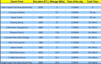 Chart.jpg |
 IMG_7007.jpg |
 IMG_7011p.jpg |
 IMG_7054.jpg |
 IMG_7085.jpg |
 IMG_7095.jpg |
 IMG_7108.jpg |
 IMG_7124.jpg |
 IMG_7131.jpg |
 IMG_7132.jpg |
 IMG_7142.jpg |
 IMG_7149.jpg |
 IMG_7151.jpg |
 IMG_7155.jpg |
 IMG_7169.jpg |
 IMG_7172.jpg |
 IMG_7175.jpg |
 IMG_7180.jpg |
 IMG_7195.jpg |
 IMG_7244.jpg |
 IMG_7246.jpg |
 IMG_7249.jpg |
 IMG_7252.jpg |
 IMG_7263.jpg |
 IMG_7275.jpg |
 IMG_7277.jpg |
 IMG_7316.jpg |
 IMG_7322.jpg |
 IMG_7324.jpg |
 IMG_7325.jpg |
 IMG_7336.jpg |
 IMG_7339.jpg |
 IMG_7340.jpg |
 IMG_7344.jpg |
 IMG_7345.jpg |
 IMG_7349.jpg |
 IMG_7350.jpg |
 IMG_7352.jpg |
 IMG_7354.jpg |
 IMG_7357.jpg |
 IMG_7358.jpg |
 IMG_7360.jpg |
 IMG_7365.jpg |
 IMG_7376.jpg |
 IMG_7406.jpg |
 IMG_7410.jpg |
 IMG_7416.jpg |
 IMG_7440.jpg |
 IMG_7441.jpg |
 IMG_7444.jpg |
 IMG_7459.jpg |
 IMG_7465.jpg |
 IMG_7470p.jpg |
 IMG_7471.jpg |
 IMG_7474.jpg |
 IMG_7490.jpg |
 IMG_7492.jpg |
 IMG_7495.jpg |
 IMG_7497.jpg |
 IMG_7502.jpg |
 IMG_7506.jpg |
 IMG_7508.jpg |
 IMG_7510.jpg |
 IMG_7512.jpg |
 IMG_7519.jpg |
 IMG_7523.jpg |
 IMG_7524.jpg |
 IMG_7530.jpg |
 IMG_7567.jpg |
 IMG_7576.jpg |
 IMG_7579.jpg |
 IMG_7581.jpg |
 IMG_7583.jpg |
 IMG_7587.jpg |
 IMG_7588.jpg |
 IMG_7597.jpg |
 IMG_7599.jpg |
 IMG_7600.jpg |
 IMG_7614p.jpg |
 IMG_7616.jpg |
 IMG_7619.jpg |
 IMG_7633.jpg |
 IMG_7634.jpg |
 IMG_7658.jpg |
 IMG_7674.jpg |
 IMG_7720.jpg |
 IMG_7731.jpg |
 IMG_7737.jpg |
 IMG_7744.jpg |
 IMG_7746.jpg |
 IMG_7747.jpg |
 IMG_7748.jpg |
 IMG_7752.jpg |
 IMG_7756.jpg |
 IMG_7762.jpg |
 IMG_7764.jpg |
 IMG_7782.jpg |
 IMG_7785.jpg |
 IMG_7786.jpg |
 IMG_7800.jpg |
 IMG_7806.jpg |
 IMG_7809p.jpg |
 IMG_7812.jpg |
 IMG_7821.jpg |
 IMG_7822.jpg |
 IMG_7845.jpg |
 IMG_7846.jpg |
 IMG_7849.jpg |
 IMG_7851.jpg |
 IMG_7852.jpg |
 IMG_7854.jpg |
 IMG_7857.jpg |
 IMG_7860.jpg |
 IMG_7862.jpg |
 IMG_7863.jpg |
 IMG_7864.jpg |
 IMG_7866.jpg |
 IMG_7867.jpg |
 IMG_7868.jpg |
 IMG_7870.jpg |
 IMG_7871.jpg |
 IMG_7873.jpg |
| comment | share |