


|
|
|
|
|
|
| |
| 01-JUL-2002 | 2002_0701_011420AA |
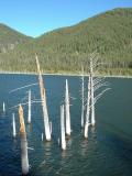
Earthquake Lake lies just outside the Yellowstone National Park's boundaries, and is due west of West Yellowstone in the Gallatin National Park.
On August 17, 1959, the largest earthquake recorded in Montana, with a magnitude of 7.3 on the Richter Scale rocked the Madison River Canyon. Earthquake Lake was formed when a giant landslide, triggered by the earthquake, blocked the Madison River. As the lake level rose, the trees around the rim of the lake were drowned. This earthquake also resulted in the disturbance of the groundwater piping in geysers at adjacent Yellowstone National Park, including a slight change in the eruption frequency of the Old Faithful Geyser from 61 to 65 minutes. Other geysers sprang to life and bubbling springs erupted violently.
photo and copyright: Ray Pettit