


|
|
|
|
|
|
| |
| 18-Jun-2019 | © Chris Gibbins |
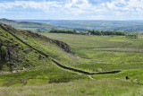
...near Once Brewed (a small village in Northunberland!)
The stone wall running diagonally across the image is part of Hadrian's Wall, a defensive fortification
of the Roman province of Britannia, begun in AD 122 in the reign of the emperor Hadrian. It ran from
the River Tyne on the North Sea to the Solway Firth on the Irish Sea, and allowed the Roman Empire
to control the north during the occupation, into the lands of the northern Ancient Britons, including the Picts.
All images are © Chris Gibbins