photo sharing and upload picture albums photo forums search pictures popular photos photography help login
Bryan Murahashi | all galleries >> 2012 Adventures >> July 28 - Eight days and 77 Miles on the Pacific Crest Trail > Day 8 trail map
previous | next

Day 8 trail map

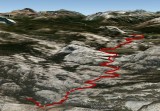
The link to the GPS plots for this 5.61 mile eighth day http://connect.garmin.com/activity/208688880
Elevation Gain: 1,021 ft
Elevation Loss: 339 ft
Min Elevation: 7,866 ft
Max Elevation: 8,661 ft


other sizes: small medium large original auto
share
Peter Stahl27-Sep-2012 03:48
Impressive hike Bryan! :-))