


|
|
|
|
|
|
| |
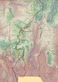
This shows New Mexico, the official Continental Divide Trail in dark red then our variants in bright red. We hiked a different starting route called the 'Columbus route' then crossed the official CDT (in the wrong direction!) for 3 miles before hiking up the Gila River. We joined the CDT proper after about 280 miles of hiking north of Snow Lake.
| comment | |