When the Franks talk about their mountain, they popularly talk about the "Walberla", the striking table mountain east of Forchheim. The correct name of the mountain massif is �Ehrenb�rg�. One of the largest Celtic settlements in the region is said to have once stood up here. 2,500 years ago, the entire plateau of this stately mountain was surrounded by a mighty stone wall. A reconstruction of this defensive wall can still be admired and the former wall can even be walked along a narrow and exciting path. The north peak is the 513.9 m high Walberla, the south peak is the 531.9 m high R�denstein.
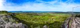
This is a pano of the north peak Walberla. On the left you see the 531.9 m high R�denstein peak, in the far distance -center- view to Bamberg with the Cathedral. In the middle of the image there are cherry trees blossoming in Spring! Around Walberla is one of the largest contiguous fruit-growing area in Europe located.
*** Must be viewed at original size ***