


|
|
|
|
|
|
| Brian McMorrow | profile | all galleries >> Europe >> Norway >> South Norway Highlands | tree view | thumbnails | slideshow |
 The road from Rysstad into the highlands of southern Norway |
 Fv337 climbing into the mountain west of Rysstad, Aust-Agder, Norway |
 Lřefjell, Brokke Alpinsenter |
 Fisstřylsĺni, Brokke Alpinsenter |
 Lřefjell, Brokke Alpinsenter |
 Our rental car in front of the cliffs of Lřefjell |
 Norwegian holiday homes, Řvre Sitĺsen, Brokke, Agder |
 Norwegian holiday homes, Řvre Sitĺsen, Brokke, Agder |
 Snow along Fv337 in June, Breivassbekken |
 Myklevatnet from Fv337 at Greinevegen, Agder |
 Myklevatnet Lake, Agder |
 Turf-roofed holiday cabin, Myklevatnet Lake |
 Turf-roofed holiday cabin, Myklevatnet Lake |
 Sandvatn Lake, Fv337, with summer snow in June |
 Verneomrĺde - Protected Area, next 23 km, Aust-Agder |
 Fv337 climbing along the south shore of Sandvatn |
 Meltwater tricking down lichen covered stones, Sandvatn |
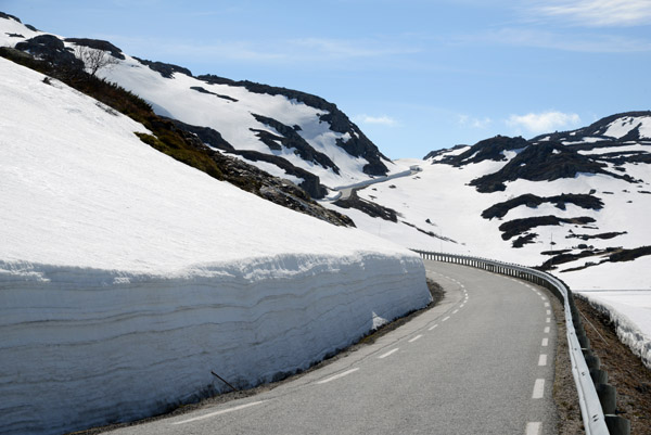
 2m+ high snowbank along Fv337, Sandvatn, Aust-Agder |
 Dennis giving perspective to the height of the snowbank |
 Fv337, Aust-Agder, Norway |
 Summer snow in June, southern highlands of Norway |
 Store Urdevatnet partially covered in ice in June |
 Snowbank along Fv337 taller than our rental car |
 Fv337 crossing the still-snowcovered southern highlands of Norway, Aust-Agder |
 Snowbank along Fv337 in June, Aust-Agder |
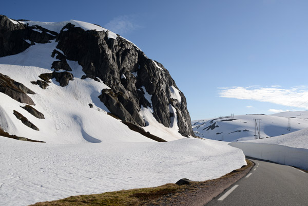
 Fv337 climbing in the southern Norwegian highlands, Aust-Agder |
 Fv337 in the southern Norwegian highlands, Valle kommune |
 Summer snow in the southern Norwegian highlands, Valle kommune, Aust-Agder |
 Fv337 in the southern Norwegian highlands, Valle kommune |
 Western edge of the Rosskreppfjorden dam |
 Leaving Aust-Agder fylke (county), Valle kommune |
 Ice covered Hĺhellervatnet on the border between East and West Agder |
 Entering Vest-Agder fylke (county), Sirdal kommune |
 Indre Flogvatn, Fv987, Sirdal kommune, Vest-Agder |
 Southern Norwegian highlands, Sirdal kommune, Vest-Agder |
 Store Kvćvebekken waterfall, West-Agder |
 Store Kvćvebekken waterfall, West-Agder |
 Store Kvćvebekken waterfall, West-Agder |
 29km on the Fv986 to Lysebotn and its 32 hairpin turns descending 800m over 8km |
 Southern Norwegian highlands with snow cover even in June |
 Lake along Fv986, southern Norwegian highlands |
 Fv986 to Lysebotn, southern Norwegian highlands, Vest-Agder |
 Southern Norwegian Highlands, Vest-Agder |
 Stream of snowmelt, Southern Norwegian Highlands, Vest-Agder |
 Fv986, Southern Norwegian Highlands in June, Vest-Agder |
 I think Ralph and Christian were a bit annoyed at my large number of photo stops... |
 Highland lake along the Fv986, Vest-Agder |
 Motorcycle dwarfed by the snowbanks along Fv986, Vest-Agder |
 Fv986 with summer snow, Southern Norwegian Highlands, Vest-Agder |
 Border from Vest-Agder to Rogaland fylke (county), Forsand kommune |
 Norwegian borderstone between Rogaland and Vest-Agder |
 Ice-covered southern Andersvatnet along Fv500, Forsand, Rogaland |
 Ice cracking on Andersvatnet, spring comes late to the southern Norwegian highlands |
 Weather-beaten historical information sign about the Lyseboten-Sirdal Road, 1985 |
 Tourist-built stone cairns off Fv500 nearing Lysebotn |
 The road to Lyseboten is normal open from May to October |
 Fv500 to Lysebotn from the Rogaland highlands, southern Norway |
 Fv500 3km from Řygardstřl, Lysebotn, Rogaland |
 Lysevegen 940, Rogaland |
 Route Map from Brokke Alpinsenter to Lysebotn through the southern Norwegian highlands |
| comment | share |