


|
|
|
|
|
|
| Brooks Rownd | profile | all galleries >> Hawai'i >> Stranded In East Hawai'i >> March 2-4, 2010 - Kulani Bird Survey | tree view | thumbnails | slideshow |
March 2, 2010
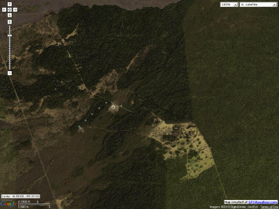
Tuesday morning was the first day of the annual Kulani Bird Survey. Since the prison is now closed there are no security checks so I was able to participate this year, and this was my first visit to Kulani. The prison opened as Kulani Honor Camp in the 1950's, with work programs for the inmates that used the Kulani parcel for forestry, ranching, farming, etc. It is a patchwork of native forests, lava fields, building complexes, pastures and alien tree plantations. The North and South edges border on large important high-canopy native forests, with numerous endangered species, and the West edge along Pu'u O'o Trail and Powerline Road has Pu'u Kipu. Kulani is like the keystone in the windward native forest conservation effort, and most of the forests have been fenced and protected over the past decade. There was also briefly a boy's facility, the Mauna Loa Boy's School, which has long been dormant. My transect was in the kipuka behind the Boy's School, so I got a good look at the depressing state of the historic building. Looks like a 3rd world prison - a square building with few windows and an interior a courtyard behind a rusty roll-up steel gate. The roof was badly damaged, and I was told it was used for military or police training at one time. The water catchment just above it is simply a concrete paved area of ground with gutters along the edges, and a huge steel tank.
My transect was in the kipuka immediately behind the Boy's School building. The forest has been pig-free for a decade or more, and looks incredibly pristine. I could imagine endangered plants living in all the nooks on the slopes inside the kipuka, though we didn't see any. The kipuka canopy was nearly all 'ohi'a, and no visible koa. In terms of the forest composition and the soil it seemed fairly young, but some of the 'ohi'a were quite large. Bird counts were typical for this elevation, like in the Saddle kipukas - though alien birds were very scarce. There was one mystery bird that rambled like a finch, but with a voice frustratingly close to an 'akiapola'au. We had 2 creepers at one station, but those were the only endangered native birds.
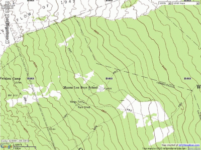
The attached maps show the 5 stations surveyed in the Boy's School kipuka, and some other stops we made. Stainback Highway (a dirt track) runs next to the Boy's School building, while Powerline Road is on the West side of the image. Pu'u O'o Trail is also shown just on the other side of Powerline Road on the topo map. The 1942 lava flow is at the top. The sharply defined grassy area just Southeast of the Boy's School was converted to cattle pasture. The main Kulani prison complex is off the bottom edge of the maps. Mauna Loa's east rift zone runs East-West through this area. To the West are the arid upper slopes of Mauna Loa, while to the East is solid rainforest. To the North is the Mauna Loa kipuka mosiac of the windward Saddle. To the South are Kulani Cone and Na Lua Mahoe, the 'Ola'a and Kilauea rainforests, and Keauhou Ranch where we counted birds last month. Oddly, the huge swath of nice forest on the East side of the image is not surveyed during the Kulani bird surveys! We only count West/upslope of Stainback Highway.
For the afternoon I went to one of the richest native forests I know of, just below Kulani along Stainback Highway. My main goal was to check the only patch of native orchids (anoectochilus) I've ever seen. I left the tree plantation trail where the rare plant concentration starts, and followed a series of muddy gullies and pits that looked promising for more rare plants. When I found the orchids they were doing quite well, with many shoots coming up in the patch, though they didn't look anywhere near large enough to flower soon. In the small area I added a few plants and trees to my rare/uncommon plants maps - kilioe, giant phyllostegia mints, cyrtandra giffardii, pilo kea, 'ohe mauka, maua, 'aiea, etc. Bird counts were a bit low, as is usual here, with the exception of 'elepaio which do well in this area.
On the way up Stainback Highway in the morning a barn owl swooped down to grab something on the road, right in my car's path. An oncoming car made it difficult to see the owl coming, and I had to leave skid marks on the road trying to avoid the owl. I didn't see the owl in my rear-view as the other car passed by the same spot, so it seems to have escaped harm.
March 4, 2010
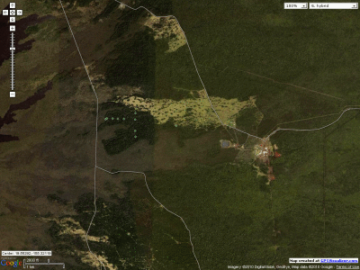
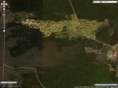
Thursday was the second and last day of the Kulani Bird Survey. We surveyed Pu'u Kipu, just above the prison complex. The wet weather continued, but like Tuesday a miraculous window of calm appeared at Kulani from 7AM-10AM that allowed us to complete the Pu'u Kipu counts in ideal weather. We followed old logging roads up to near the "summit" of the pu'u and did transects 6 and 7. They are shown on the attached satellite photo map. Mauna Loa's upper elevation lava fields and scrub forest are upslope to the West, and the windward rainforest is downslope to the right. The grassy area is former cattle pasture for the prison's ranching operation, and the central prison complex is on the right side of the image. Mauna Loa Boy's School is near the top edge. Keauhou Ranch and the "Kilauea Forest", which we surveyed earlier, is at the bottom.
The Pu'u Kipu forest was a bit more diverse than the Boy's School forest. There were a lot of kolea, naio and koa in the canopy, and a number of 'oha wai in the understory. There was a pocket of endangered clermontia lindseyana near one of the stations, and one plant had flower buds just ready to open. It was the first time I've seen wild plants of this species (not outplants) and its flowers. We were too busy for photos, though.
Bird counts were very similar to the Boy's School counts, and very similar to Powerline Road counts. We did not have any endangered birds during the counts, but passed a couple of 'akepa on the way out.
It was raining steadily when we departed Kulani at noon, so I spent the afternoon doing something unusual - I walked along the southeastern end of Tree Planting Road for the first time. I don't go here much because it is very weedy, and there are usually hunters out. With all the rain it was deserted. Tree Planting Road is lined with plantations of Mexican ash, trema and eucalyptus, which are also invading surrounding native forest. The native forest was bulldozed down in blocks, creating a grid of various alien tree species plantations. The understory is being consumed by some of the nastiest alien weeds in Hawai'i, such as strawberry guava, tibouchina, clidemia, etc. However, there are still pockets of native plants. A few older native trees were left in place. The most common native trees are growing in the understory. Naupaka kuahiwi and 'oha wai were plentiful along the roadside, and patches of haiwale, pa'iniu, haha (cyanea pilosa) are growing in the understory. Native loulu palms were scattered along the entire distance of the road that I covered. I got halfway from Stainback Highway to the 1942 lava flow before I ran out of time, and it rained off-and-on the whole time. Bird counts were low, with small numbers of 'apapane and Japanese white-eye each count, and scattered Japanese bush warbler, house finch, 'oma'o and hwamei. At the point where I stopped to turn around I magically found a small huperzia (large club moss) - wawae'iole - growing on a log over one of the plantation skid roads. I don't see many huperzia, though they're widespread.
3/2/2010 Kulani Bird Counts: (Species Codes Here)
| station | time | APAP | IIWI | HAAM | OMAO | ELEP | HCRE | JAWE | KAPH | Notes |
|---|---|---|---|---|---|---|---|---|---|---|
| Kulani 11-1 | 0725 | 22 | 1 | 3 | 3 | 1 | ||||
| Kulani 11-2 | 0749 | 14 | 4 | 2 | 2 | 1 | ||||
| Kulani 11-3 | 0812 | 15 | 3 | 3 | 3 | 1 | 1 | 1 | ||
| Kulani 11-4 | 0838 | 14 | 4 | 2 | 2 | 1 | 1 | |||
| Kulani 11-5 | 0901 | 11 | 5 | 1 | 1 | 1 | ||||
| solid forest to the east | 1010 | 12 | 2 | 3 | 4 | |||||
| station | time | APAP | IIWI | HAAM | OMAO | ELEP | HCRE | JAWE | KAPH | Notes |
3/2/2010 Rainforest Bird Counts: (Species Codes Here)
| station | time | APAP | HAAM | OMAO | ELEP | JAWE | NOCA | JABU | Notes |
|---|---|---|---|---|---|---|---|---|---|
| mdn00 | 1152 | 7 | 4 | 2 | 3 | 1 | Stainback Highway | ||
| mdn02 | 1206 | 6 | 2 | 2 | 3 | 1 | |||
| mdn05 | 1218 | 10 | 2 | 3 | |||||
| mdn09 | 1235 | 5 | 2 | 1 | 2 | ||||
| mdn09 | 1251 | 4 | 1 | 2 | 1 | ||||
| mdn0903w | 1340 | 6 | 3 | 1 | 3 | ||||
| mdn0903w | 1438 | 8 | 2 | 1 | 1 | ||||
| mdn0903w | 1545 | 9 | ? | 2 | 1 | 1 | |||
| mdn12 | 1635 | 5 | 2 | 2 | |||||
| mdn12 | 1731 | 9 | 2 | 1 | |||||
| mdn12 | 1814 | 5 | 3 | 1 | 1 | 1 | Stainback Highway | ||
| station | time | APAP | HAAM | OMAO | ELEP | JAWE | NOCA | JABU | Notes |
3/4/2010 Kulani Bird Counts:
(Species Codes Here)
| station | time | APAP | IIWI | HAAM | OMAO | ELEP | AKEP | JAWE | NOCA | KAPH | Notes |
|---|---|---|---|---|---|---|---|---|---|---|---|
| Kulani 7-1 | 0746 | 12 | 4 | 1 | 3 | 1 | 2 | ||||
| Kulani 7-2 | 0808 | 15 | 3 | 5 | 3 | 1 | 1 | ||||
| Kulani 7-3 | 0830 | 19 | 2 | 1 | 3 | 2 | |||||
| Kulani 7-4 | 0850 | 15 | 3 | 1 | 1 | 2 | 1 | ||||
| Kulani 7-5 | 0914 | 16 | 4 | 1 | 3 | 1 | |||||
| Kulani 6-5 | 0949 | 18 | 2 | 4 | 1 | 1 | 3 | ||||
| Kulani 6-6 | 1010 | 13 | 2 | 1 | 4 | 1 | 1 | 1 | |||
| station | time | APAP | IIWI | HAAM | OMAO | ELEP | AKEP | JAWE | NOCA | KAPH | Notes |
3/4/2010 Tree Planting Road Bird Counts:
(Species Codes Here)
| station | time | APAP | OMAO | JAWE | HOFI | JABU | MELT | KAPH | Notes |
|---|---|---|---|---|---|---|---|---|---|
| TPR 0.0km | 1328 | 1 | 3 | 1 | 1 | ||||
| TPR 3.0km | 1435 | 2 | 1 | 5 | 2 | ||||
| TPR 3.0km | 1500 | 2 | 1 | ||||||
| TPR 4.0km | 1525 | 1 | 3 | 1 | |||||
| TPR 1.0km | 1637 | 5 | 1 | 3 | 2 | ||||
| station | time | APAP | OMAO | JAWE | HOFI | JABU | MELT | KAPH | Notes |
 kulani_02mar10.gif |
 kulani_02mar10topo.gif |
 kulani_04mar10.gif |
 kulani_04mar10a.gif |
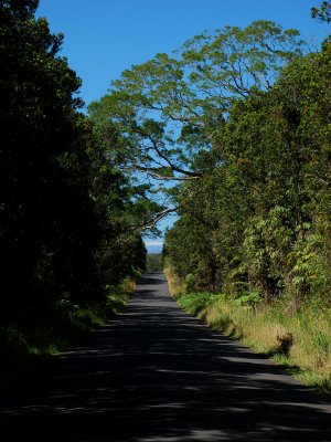
[ Stainback Highway ] |