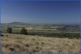
This photo was taken from the top of Round Butte and gives a good overview of the Grasslands.
The national grasslands program is administered by the US Forest Service and the Crooked River is the largest one west of the Mississippi and encompasses 155,000 acres of drought-stricken homestead lands dating back to 1880 that the US Government bought up. Over 700 families homesteaded this area but during the drought and Great Depression, all but 50 families left. The abandoned lands and buildings were bought up by the government to provide relief to the homesteaders. When crested wheat grass was finally introduced, the land began to flourish.
The Grasslands still show evidence of homesteaders such as stone shelters, tools ,cans, log cabins, barns and water troughs as a reminder of their brief presence and tragic history.