


|
|
|
|
|
|
| Birgit | profile | all galleries >> Galleries >> Motorcycle Trip July/August 2003 | tree view | thumbnails | slideshow |
| previous page | pages 1 2 3 4 5 6 7 8 9 10 11 12 13 14 15 16 ALL | next page |
 11 Days - 8 States - 3'577 Miles |
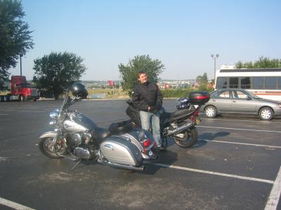
 Thursday 7/24/2003 - We have an early morning start. |
 Highway 80 - right across the Illinois border in Iowa - potty stop. |
 Another pit stop - look at the German Willkommen sign. |
 A yellow hitchhiker on my mirror. |
 The next morning, Friday 7/25/03, ready to hit the road again, after a yummy steak and a good night's sleep in Omaha, Nebraska. |
 Where all the big truckers stop you can certainly get the best breakfast. |
 North Platte, Nebraska - it is hot, hot, hot - 113 degrees Fahrenheit = 45 degrees Celsius !!! |
 Not even sitting in the shadow for a little while brings relief. |
 But somehow we make it to Buffalo Bill's ranch. |
 The barn and stables, |
 and the house where William F. Cody - Buffalo Bill - lived. |
 Claus trying a different kind of saddle. |
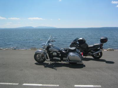
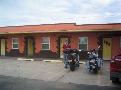 7/26/03 - In front of the Palomino Motel in Sidney, Nebraska, where we spent the night. |
 We are heading towards Cheyenne, Wyoming. This is probably the oldest gas station we have ever seen. |
 Our first 1'000 Miles - 7/26/2003 10:40 am. |
 Cheyenne, Wyoming, has Frontier Days and a Rodeo each year during the last week of July. |
 A blacksmith shows how his profession worked about one hundred years ago. |
 And then we watch the Rodeo - yeeHa ! |
 And a little more Rodeo. |
 And some more. |
 Claus with his new hat - that's what the Rodeo does to you ! Bye-bye Cheyenne, we gotta go. |
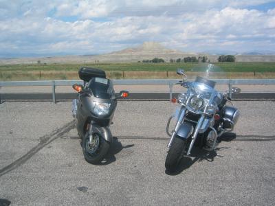
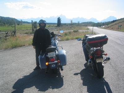
 From Cheyenne we take Hwy 26 towards Casper, Wyoming, and with every mile the mountains are getting a little closer. |
 Sunday 7/27/03, we leave Casper in the morning, and about 40 miles northwest, quite unexpectedly, we find this unique place. |
 But should we really take a break here ? |
 Hell's Half Acre is actually a 320 acre canyon, and a very surreal example of nature. |
 About 50 Million years ago the earth was shifting and left behind |
 this fantastic depression with |
 jutting rock formations and hidden caves. |
 The native Americans used this canyon for hunting Buffalo. |
 A hord of buffalo was driven into the canyon, thus had no more escape route, and could easily be killed. |
 And by just looking at the play of light , shadow, and colour we can understand |
 that there are many stories haunting these hills. |
 Hell's Half Acre, Wyoming |
 We are heading further west on Hwy 26 |
 and it almost seems like we are in nowhere-land, sometimes we don't even see mailboxes at the side of the road anymore. |
 Part of our route leads us through the Wind River Reservation, which is home of the Eastern Shoshone and Northern Arapaho tribes |
 One very famous battle between the Shoshone and Bannock on one side, and the Crow on the other, was fought at Crowheart Butte |
 The Wind River Reservation is with 2.2 Million Acre the third largest in the United States. |
 The Big Wind River and Little Wind River run through the reservation. |
 The reservation known to the Shoshone as �Warm Valley� is surrounded by the Wind River Mountain Range to the west, |
 the Owl Creek Mountain Range to the north, and the Absaroka Mountains to the south. |
 And the further we go the hillier it gets. |
 But still not a soul to see. |
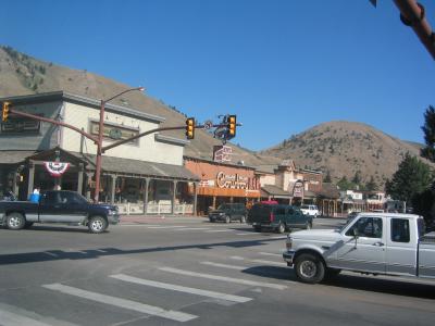
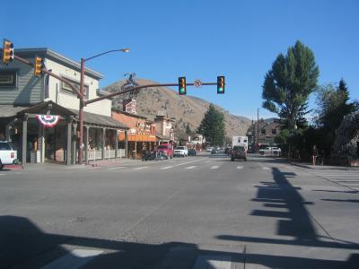
 And all of a sudden, almost out of nowhere, Dubois appears. |
 Everything in Dubois, Wyoming is in Western style and very inviting, |
 so we stop for a cold Coke in this little Bar. |
 But we are anxious to leave again because we are about to climb our first mountain pass. |
 Togwotee Pass with an elevation of 9'600 feet has lots of fun twisties and allows us first glimpses of the Teton Mountain Range. |
 On the way down the pass - Claus a little off the road ! |
 If this is Moran Junction then Jackson can't be that far away anymore ? |
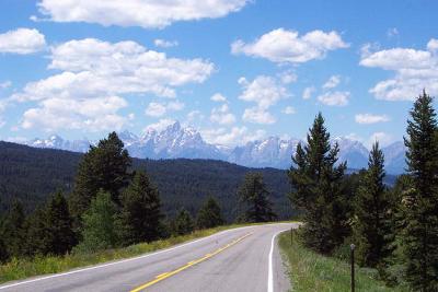
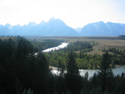
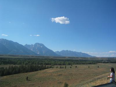
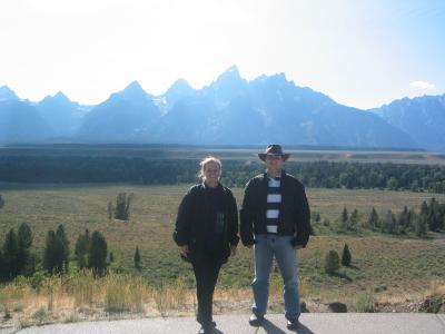
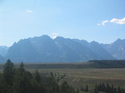 And finally, we are right in front of the Grand Tetons - awesome ! |
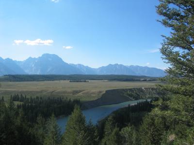 Grand Teton Mountain Range with the Snake River in front. |
 The Snake River originates in the Tetons and runs in and out of Jackson Lake, and forms the headwaters for the Columbia River. |
 Grand Teton rises to 13'770 feet, and twelve of the Teton peaks in the mountain range rise above 12'000 feet, |
 more than a mile above the valley below, known as Jackson Hole. |
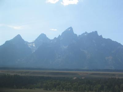 The Teton Range is the youngest range in the Rockies - only about 9 million years ago today's Teton Range started rising. |
 Over a comparatively short span of time, mountain glaciers of the last major glacial period |
 shaped the Teton skyline more than any other erosional force. |
 The Teton Mountain Range is 40 miles long (65 km) and 7-9 miles wide (11-14.5 km). |
 The mountain valley Jackson Hole is 55 miles long (89 km), 13 miles wide (21 km), with an average elevation of 6'800 feet. |
 The Town of Jackson is the county seat of Teton County and the only incorporated municipality in the county. |
 Jackson is a popular tourism destination because of its closeness to Yellowstone & Grand Teton National Parks. |
 Jackson is a skiing mecca during the winter with three challenging ski areas, |
 and Claus and I already dream about skiing and snowboarding here sometime soon. |
 Monday morning 7/28/2003 - we are heading towards the south entrance of the Grand Teton National Park, |
 the mountains always in sight, loading our inner batteries. |
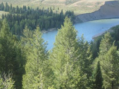
 A little further north into the park we come to Jackson Lake, a large natural glacial lake. |
 Jackson Lake sits at an elevation of 6'772 feet, when full, and is fed by snowmelt and cold spring water by the Snake River. |
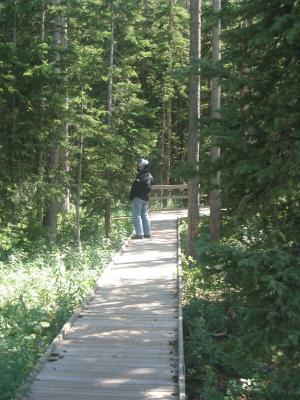
 Claus is testing the water, but unfortunately we don't have time for a swim, we are heading north to Yellowstone National Park. |
 Established on March 1, 1872, Yellowstone National Park is the first and oldest national park in the world. |
 High above the Lewis River we can still see the impacts of the last big forest fires in 1988 that burnt about 36% of the park. |
 Many people thought that Yellowstone would never recover, but fire is also a necessary part of the cycle of life in a forest. |
 Lewis Falls - Claus and I taste the water, it is fresh and crisp, but people around us only shake their heads in disbelief. |
 A little further along the road we see deer grazing, |
 peacefully and not at all impressed or disturbed by the photo-shooting tourists. |
 Our next stop is Old Faithful, the biggest regular geyser in Yellowstone. |
 Old Faithful erupts every 35 to 120 minutes for 1 1/2 to 5 minutes, its maximum height ranges from 90 to 184 feet. |
 We have to wait for more than 25 minutes, during which Old Faithful only shows some peaceful bubbling and a bit of steam. |
 And all of a sudden the bubbling turns into hissing |
 and Old Faithful finally erupts. |
 Water is spurting high into the sky |
 creating a curtain of steam |
 that looks impressive against the deep blue sky. |
 But not at all impressive is the smell of sulphur all around us. |
 After a few minutes of hissing and spurting Old Faithful becomes calm again |
 and goes back to its peaceful bubbling and steaming, and all the tourists leave again. |
 We are not quite sure whether these trees close to Old Faithful died from the stinky sulphur steam |
 or from the big forest fires. |
 Preserved within Yellowstone are approximately 10'000 hotsprings, mudpots, fumaroles, and geysers. |
 These geothermal features are evidence of one of the world's largest active volcanoes; |
 its last eruption (2 million years ago) created a crater or caldera that spans almost half of the park. (Photo = Emerald Spring) |
 Pathways are built to give tourists the closest possible access, but soon sulphur smell and sauna-like heat are too much for us. |
 Shortly before we reach the Madison Junction, we discover this hidden treasure - |
 Firehole Canyon Drive - a small one way road along the Firehole River and passing Firehole Falls. |
 One and a half miles of pure excitement, steep climbs, narrow twisties and turns, and - the best - no traffic and no police. |
 As we reach the main road again we see elk basking in the last sunlight of the day. |
 Because it is already late in the day we are the only visitors, and the elk are absolutely undisturbed. |
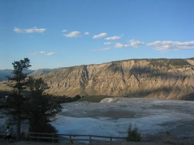 Our last destination for the day is Mammoth Hot Springs. Here the Main Terrace and Mount Everest (7'841 feet) in the background. |
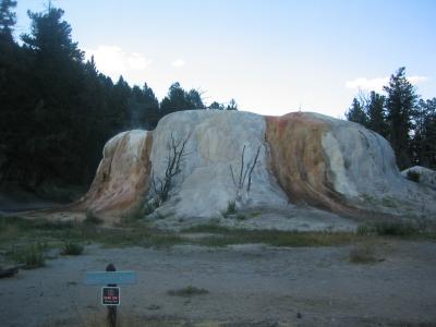 Bacteria and algae create the color on Orange Spring Mound. Its shape is from very slow water flow and mineral deposition. |
 Angel Terrace was dry for decades but recently hot springs have been active in parts of the formation. |
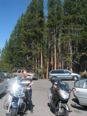
 We leave Yellowstone through the North Entrance in Gardiner, Montana, where we spend the night. |
 Tuesday morning 7/29/03 - we go back to Mammoth Hot Springs and across the Blacktail Deer Plateau |
 to Tower Falls, the second most popular falls, which drops 132 feet into the canyon below. |
 From there we climb Dunraven Pass at 8'856 feet, with the Yellowstone River deep down below us, and Mount Washburn (10'243 ft) |
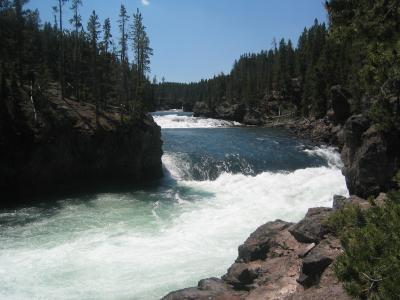
 leading us to The Grand Canyon of the Yellowstone. |
 Yellowstone's Grand Canyon may not be as big as the Grand Canyon in Arizona, but it is nonetheless breathtaking. |
 The view down on the Yellowstone River from Artist Point, |
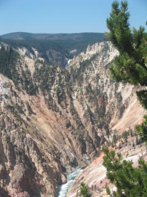 with the Lower Falls in the background. |
 The canyon is roughly 20 miles long, measured from the Upper Falls to the Tower Fall area. |
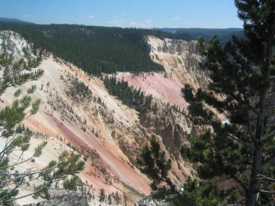 The canyon as known today is a relatively young geologic feature, it is no more than 10'000 to 14'000 years old. |
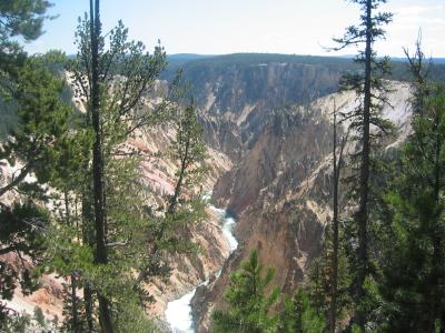
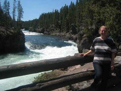
 We drive a little further south into the canyon |
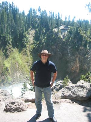 where we can walk down to the brink of the Lower Falls |
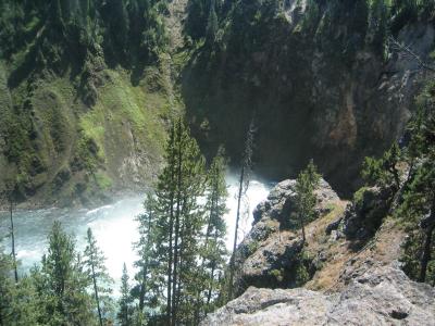 Lower Falls is 308 feet high. |
 The Lower Falls is often described as being more than twice the size of Niagara, |
 although this only refers to its height and not the volume of water flowing over it. |
 The volume of water flowing over the falls can vary from 63'500 gal/sec at peak runoff to 5'000 gal/sec in the fall. |
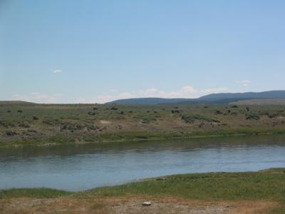 Our next destination is Fishing Bridge about 26 miles south, and along the roadside we see a buffalo herd. |
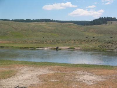 Just like the deer and the elk yesterday, the buffalo are completely unmoved by the many tourists staring at them. |
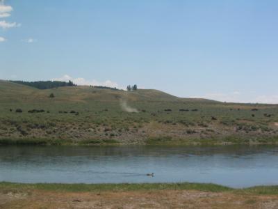 They simply ignore us, even snort and produce big dust clouds. |
 After a short pit stop in Fishing Bridge this little beauty is waiting at my windshield, but I don't want to give him a ride. |
 From Fishing Bridge we go east and ride along the winding shore of Yellowstone Lake, |
 the largest high altitude lake in the US (7'733 feet). This is the view from Mary Bay. |
 The road to Yellowstone's East Entrance leads us across Sylvan Pass at an altitude of 8'530 feet. |
 We stop and take a last look back at Yellowstone National Park, |
 and we both make a silent promise to come back soon. |
 From there our route leads us to Cody, Wyoming, about 53 miles from the East Entrance. |
 Shortly before we arrive in Cody we drive through the Buffalo Bill State Park, |
 which is dominated by a big dam, retaining the waters of the Shoshone River. Colonel Cody was influential in bringing irrigation |
 and agricultural development into the area and founded the town that bears his name. |
 From Cody we take US 14 East through the Bighorn National Forest. It is already late afternoon, |
 and with every mile it is getting cooler. We climb Granite Pass at an altitude of 8'950 feet, and at the peak |
 we are freezing and change into our warmer gear. So prepared we arrive in Sheridan, Wyoming, at around 7:30 at night. |
 We take Hwy 90 east for the next 250 miles and arrive in Rapid City, South Dakota long after midnight. |
 Luckily, Luke arrived earlier and already found us a motel, so we can collapse into our beds right away. |
 Too early the next morning, Wednesday 7/30/03, we are heading to the Mount Rushmore National Memorial. |
 Mount Rushmore National Memorial is located 23 miles southwest of Rapid City, in the Black Hills of South Dakota. |
 It memorializes the birth, growth, preservation and development of the United States of America. |
 Between 1927 and 1941, Gutzon Borglum and 400 workers sculpted the 60-foot busts of Presidents George Washington, |
 Thomas Jefferson, Theodore Roosevelt, and Abraham Lincoln to represent the first 150 years of American history. |
 Washington represents the struggle for independence, Jefferson the idea of government by the people. Lincoln was chosen for his |
 ideas on equality and the permanent union of the states, and Roosevelt for the 20th century role of the US in world affairs. |
 At Lunch Luke and Claus see this picture of the Iron Mountain Road in the men's bathroom, should we be scared ? |
 This winding road extends between Mount Rushmore and Hermosa, in the northeast corner of Custer State Park. |
 Along the highway are pigtail bridges. three tunnels, steep climbs, and narrow twists as well as hairpin turns. |
 Motorcyclist's paradise ! And on top of Iron mountain the view of the South Dakota Black Hills is wonderful. |
 In the distance we can even see Mount Rushmore one more time. |
 This is the sight I had in front of me for now close to 3'000 miles. |
 On the road through Custer State Park we are stopped by donkeys. Some drivers even feed them. |
 And then we see free roaming Bison again right next to the road. |
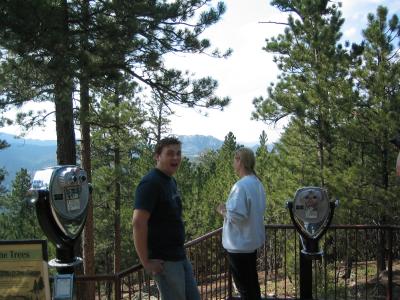
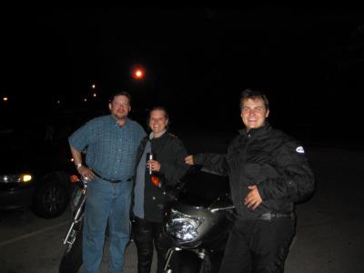
 Luke and Claus |
 Claus can heardly wait to hit the road again, we are heading to Needles Highway. |
 Needles Highway in Custer State Park is an exciting area for motorcycle riding |
 consisting of tight turns and some tough climbs, this highway gets its name from the interesting rock formations |
 that look like large needles sticking out of the ground. |
 This highway is very narrow and there are some small rock tunnels that are so tiny that tour busses barely fit through them. |
 Claus coming through one of those tunnels that leads us directly to |
 one famous rock formation, called Needles Eye. |
 Claus, Luke, and I in front of the tunnel. |
 We see some more granite rock formations before the day slowly comes to an end |
 and we need to ride back to Rapid City. |
 At dinner this evening Luke and Claus play a quiz game, and we have a lot of fun. |
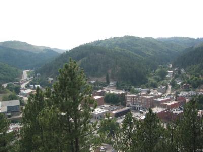
 The next morning, Thursday 7/31/03, we visit Deadwood, South Dakota, an old Western Town. |
 The city was founded following the discovery of gold in 1876. (Photo = Main Street) |
 Many old hotels and historic saloons are preserved here, |
 and shoot-outs take place in various locations throughout the day. |
 Claus with one of the very dangerous gun-slingers. |
 James Butler "Wild Bill" Hickok was shot in Deadwood and is buried in the Mount Moriah Cemetery, |
 Deadwood's famous Boothill. Right next to him Calamity Jane has her last resting place. |
 The view from Boothill down on the city of Deadwood. |
 Deadwood is only about 15 miles away from Sturgis, where the 63rd Annual Motorcycle Rallye is about to start, and we can see |
 all different kinds of crazy motorcycles. And since we are already in the area, why not visit Sturgis and see what it's like. |
 Different kinds of shops are set up, and bars and restaurants are ready to welcome the thousands of riders coming this weekend. |
 For us it is already crowded enough and we cannot even begin to imagine what it will be like next week. |
 Even the parking lot of our hotel looks like part of Sturgis this night. |
 Friday morning, 8/1/03, we take Hwy 90 east and stop at Wall Drug, a sprawling tourist mall/trap, |
 occupying the majority of downtown Wall, South Dakota, also known as "the geographical center of nowhere". |
 Another twohundred-and-something miles later, still in South Dakota, which is now "flat as a pancake". |
 Almost 600 miles behind us today, still about 30 more to go until we reach Bloomington, Minnesota, |
 and Claus is not the least little bit tired ! |
 600 miles of bugs on the visor of the helmet :-) |
 On Saturday, 8/2/03, we spend all day in the Mall of America, and this night our feet hurt instead of our butts. |
 And on Sunday morning, 8/3/03, we saddle our steel horses for the ride home. |
 And from La Crosse, Wisconsin until home, more than 250 miles, the sky is crying with us that our trip is over. |
 * * * THE END * * * |
| previous page | pages 1 2 3 4 5 6 7 8 9 10 11 12 13 14 15 16 ALL | next page |
| comment | share |
| Guest | 15-Aug-2005 02:04 | |
| Frank | 04-Feb-2005 18:27 | |