photo sharing and upload picture albums photo forums search pictures popular photos photography help login
Sunbird Photos by Don Boyd | all galleries >> Airports and Airport Construction Photo Galleries >> Miami Municipal Airport / Amelia Earhart Field and All-American Airport / Masters Field / Naval & Marine Corps Air Station Miami > 1947 - Miami Municipal Airport (later Amelia Earhart Field) in foreground, Masters Field in background
previous | next
1947

1947 - Miami Municipal Airport (later Amelia Earhart Field) in foreground, Masters Field in background

Northwest Dade County, Florida


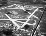
The view is looking east-north-east with LeJeune Road in the foreground on the west border of Miami Municipal Airport (renamed to Amelia Earhart Field on October 26, 1947), the Little River Canal on the right (southern) border), and NW 27 Avenue on the eastern border of Masters Field. NW 119 Street is visible at the top intersecting 27th Avenue at the east side of Masters Field. The taxiway over the Seaboard Air Line Railroad tracks connecting the two airports is still visible but was eliminated later.


other sizes: small medium original auto
comment | share
Sunbird Photos by Don Boyd15-Feb-2008 06:22
That site is excellent but he has the incorrect location described for Miami Municipal/Amelia Earhart Field. It was not at NW 103 Street. Don
Erik 13-Feb-2008 01:52
You can find www.airfields-freeman.com for more information on this airport and others in the Miami area.
Back in 62, I was on my first airliner ride and I think it was this airport that we flew over and it had telephone poles running down the center of the some of the runways.