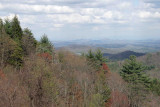
My last shot of the day. This is looking into the direction of Blairsville/Blue Ridge. After this stop we drop quickly into the valley near Blue Ridge. Within 5 minutes we were back to 45mph on the paved section of old highway 2 entering Blue Ridge.
My wife and I travel from Monticello, Ga to Chatsworth to a friends cabin she let's us stay in about 3 miles before the State Park coming from Ellijay, and We would like to experience the trip through Cohutta. Is the map you mentioned the one that DNR and FOREST Service sells of the Chattahoochee National Forest or is it a map just for Cohutta? If it's the forest map, I have one that I bought last time I visited the Cabin, but if it's different, can you tell me where I can get one and specifically what to ask for when getting one? Thanks and we can hardly wait to travel this 4.5 hour scenic trip through OUR GEORGIA MOUNTAINS. Thanks again and keep those awesome pictures coming. Good job, bud. Paul
Paul Eskew
03-Oct-2016 21:03
Mark, I just finished taking your trip with you two and your pictures are so crisp and clear and of some of the most beautiful views and creeks and mountain sceneries I have see in a while. Thank you for posting and narrating this show. Sincerely, Paul V. Eskew