


|
|
|
|
|
|
| |
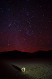
Death Valley
The Racetrack Playa is 3608 feet above sea level, and 2.8 mi long (north-south) by 1.3 mi wide (east-west).
The playa is exceptionally flat and level with the northern end being only 1.5 inches higher than the southern. This occurrence is due to major influx of fine-grained sediment that accumulates at the north end. The highest point surrounding the Racetrack is the 5,678 feet high Ubehebe Peak, rising 1970 feet above the lakebed 0.85 mile to the west.
The playa is in the small Racetrack Valley endorheic basin between the Cottonwood Mountains on the east and Nelson Range to the west. During periods of heavy rain, water washes down from the Racetrack mountain area[1] draining into the playa, forming a shallow, short-lived endorheic lake. Under the hot desert sun, the thin veneer of water quickly evaporates leaving behind a surface layer of soft slick mud. As the mud dries, it shrinks and cracks into a mosaic pattern of interlocking polygons.
The shape of the shallow hydrocarbon lake Ontario Lacus on Saturn's moon Titan has been compared to that of Racetrack Playa.
GO 2... https://youtu.be/JFFhD5HeByM
(C) William G. Hartshorn www.WGHartshorn.com All images are protected by copyright law.