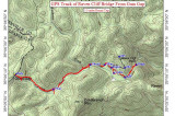
Happy New Year everyone! Hope you were able to get out for a New Year's Day hike. I called Bernie to throw around ideas for our hike and he came up with a good one. I mentioned a return trip to Raven Cliff Falls near Caesar's Head SP in SC and he asked if I had ever been to the bridge at the top of the falls. I hadn't and he knew a back way in which would make the round trip hike 5 miles instead of 9 miles. The hike was excellent and fairly easy - moderate at the most. There are a couple of small creek crossings and one bigger one across Matthews Creek that may require wading if the water is way up. Bernie prepared the topo image shown here and below are the directions if you are interested.
To get to the parking. Take US 276 south from Brevard towards Connestee Falls. Drive about 1.5 miles past Connestee and turn right on East Fork Rd. This leads to the back entrance of the Connestee Falls development. Drive 1.4 miles down East Fork and turn left on the gravel Happy Acres Rd. Drive 3.3 miles down Happy Acres Rd and park at the gates without blocking them. Happy Acres Rd is in decent shape, but narrows to one lane with pullouts once you pass the sign for the Watson Cooper Heritage Preserve and the last residential driveway to the right signed 'George'. Begin the hike past the gated road on the left with the blue blazes on the trees. This is a spur trail for the Foothills Trail, but also connects with the pink blazed trail in the Mountain Bridge Wilderness Area. The trail/road begins with a descent, but soon levels out. In 15-20 minutes the trail forks - stay to the left and continue following the blue blazes. In another 15-20 minutes (depending on how fast you hike) come to the crossing of Matthews Creek. We crossed on the small rocks to the right and managed to keep our feet fairly dry. Once across, continue on the trail for another 10 minutes and come to an intersection and another sign for the Watson Cooper Heritage Preserve. Continue on the blue blazed trail and soon come to another fork. The blue blazed trail continued left - and you can stay on it - but we took the right trail/road and continued on it for maybe 10 more minutes. Look for a newer 'no trespassing' sign nailed to a tree on the right, then continue to a second sign on the right. Go past this for about 20-30 yards and look for a faint trail to the left heading up. If you go too far you will come to a creek. Take this trail up about 100' and connect with the pink blazed trail. Head to the right and down to Matthews Creek and on down to the bridge above the waterfall.