


|
|
|
|
|
|
| |
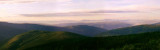
This is a panorama of the view north from the Top of the World Highway taken at around 11:00pm. The long twilight was a welcome bonus while I traversed the challenging road to Dawson.
As on the Taylor Highway it also took me a long time to traverse the Top of the World Highway due to the difficult terrain and the long distance to Dawson City. Again, I didn't fancy having to camp out in the open where a bear might show up in the middle of the night. Fortunately the sun sets very late at these latitudes in summer so I had some extra time and it didn't really get completely dark even after sunset so I continued pedalling towards Dawson City which I reached at 2:00am in the morning, after having covered a total of 180km since leaving Chicken in the morning.
The Top of the World Highway connects Dawson City with the Taylor Highway in Alaska. There is a free ferry service crossing the Yukon river at Dawson City. The canadian side of the Top of the World Highway is sealed and in significantly better condition than the Alaskan side and the Taylor Highway, but is it still a winding road with many steep hills. The name derives from the road mostly following the hilltops and often providing stunning views over the surrounding valleys.
Copyright Rolf Wahl Olsen 2011