photo sharing and upload picture albums photo forums search pictures popular photos photography help login
Rod Ostoski - Brevard County Real Estate Photographer | all galleries >> Galleries >> Merritt Island Wildlife Refuge > MIWR Map for Photographers
previous | next

MIWR Map for Photographers

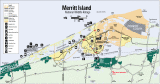
If you plan on visiting this area here is an accurate map that you can download. I have marked red check marks next to Black Point, Gator Creek, Bio Lab Rd, Scrub Jay park and the Blue Heron Wetlands. Click on "Original" link below to get full res map.


other sizes: small medium large original auto
previous | next
comment | share
Guest 15-Jan-2005 16:24
Rod your provocative and fantastic images have me longing to visit. Hope to get over your way some day to see all that your backyard has to offer. You are too kind to share this map with everyone.