


|
|
|
|
|
|
| |
| 07-FEB-2012 | |
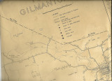
see next photo in gallery for the key to this map. Map drawn for the Gilmanton Historical Society in 1966. Map notes local dwellings and the inhabitants in 1966 and in 1860. Of note: In 1860 Manning Lake was known as Young's Pond. The key notes that several of the dwellings in the area were inhabited by Young families. Crystal Lake was known as Lougee Pond and there were several Lougee families in the area. Sunset Lake was known as Place's Pond. One Place family is noted as living at #51 on the map. The Place famiy built the dam and sawmill at the outlet of Sunset Lake / Place's Pond. Note the stream running from Place's Pond to Crystal Lake is called Mill Brook.
subject to Fair Use