If we had the opportunity to comment on where the SSTIK waypoint might be moved to:
When are noise events created in Brisbane? Is it when the planes fly north over the water or is it when they turn west and south over land? The noise data is very clear. The events are recorded when the planes turn west and south over our city. So how to reduce these noise events? It is better for the noise in Brisbane for the planes to fly further north than the current SSTIK waypoint and then turn west and south. Thus move the waypoint further north back to the old SEPDY waypoint location.
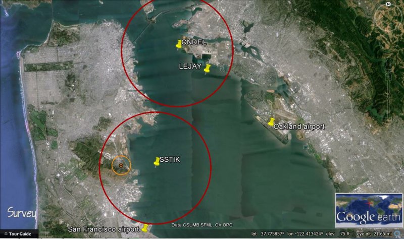
But is moving the waypoint back to the SEPDY position, technically feasible? Yes there is a half mile plus distance between the 3 nautical mile rings around SSTIK and CNDEL. And the SEPDY procedure has been flown for 20+ years. It is tried and tested. It was the SID departure.
Alternatives:
1) Move waypoint east 1/2 mile of current position: If the current patterns are flow, this will bring the planes that currently fly 1/2 mile to the west of Brisbane, over Brisbane. Potentially a lot worse for Brisbane with many more noise events
2) Move waypoint east 1/2 mile of current position and have an additional waypoint further north: This may work. The CNDEL procedure has an intermediate waypoint, LEJAY (see photograph above). It depends on the FAA agreeing to the additional waypoint and then flying the procedure. The experience of the current CNDEL where 10% fly the procedure and 90% are vectored, does not give comfort.
3) Move waypoint back to SEPDY position: Guaranteed less noise in Brisbane.
The big issue is whether the FAA will fly the revised procedure. The November 1-15 2015 figures of 50% flying through 1/8 mile radius circle around SSTIK and 10% through 1/8 mile radius circle around CNDEL, raises the question:
- why are the procedures not being flown 90% of the time. I am taking 10% off as there must be situations when flights off Oakland force the SSTIK flights to be vectored.
Thus a follow up question becomes:
- why did the FAA design the SSTIK and CNDEL RNAV procedures to require manual involvement?
I understood that one of the principles of the RNAV procedures design was to improve efficiency and thus an implied reduction in manual involvement.