


|
|
|
|
|
|
| |
| 09-SEP-2010 | D. Bibby |
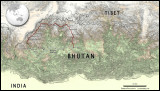
Map showing the Snowman trek (in red) and other places of interest.
Topographic data is Shuttle Radar Topographic Mission data acquired by NASA. Image processing and cartography by D. Bibby.
Please click the 'original' link below to view the full sized image.
| comment | |