photo sharing and upload picture albums photo forums search pictures popular photos photography help login
Jola Dziubinska | all galleries >> AMERICAN SOUTHWEST 2013 >> DEAD HORSE POINT STATE PARK > Dead Horse Point - Eastern Vista
previous | next
22-MAR-2013 Jola Dziubinska

Dead Horse Point - Eastern Vista

Moab, Utah

Looking east most of the potash evaporation ponds at Potash, are visible here.
The Moab or Cane Creek potash mine is located along the right (northwest) bank of the Colorado River, about 20 miles (30 km) west of Moab.
River water is pumped into the mine and dissolves the potash, after which the brine solution is pumped to evaporation ponds.
A rock tower on the left is called on the maps as "Point 5822."
The ridge at the right end of the ponds is part of Pyramid Butte. The dirt road is Shafer Trail.
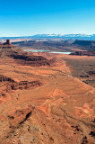
Beyond the tilted strata is a bizarre landscape of sandstone forms and valleys called "Behind the Rocks". Moab is located behind this, in a valley.
And the La Sal Mountains in the distance.

Nikon D700 ,Nikkor AF-S 24-70mm f/2.8G ED
1/500s f/11.0 at 31.0mm iso200 hide exif
Full EXIF Info
Date/Time22-Mar-2013 11:29:04
MakeNikon
ModelNIKON D700
Flash UsedNo
Focal Length31 mm
Exposure Time1/500 sec
Aperturef/11
ISO Equivalent200
Exposure Bias-0.67
White Balance
Metering Mode
JPEG Quality
Exposure Program
Focus Distance

other sizes: small medium original auto
share
Shmuel Halevi01-Jun-2013 06:01
Terrific view. Have been there myself two weeks ago...
Commenting on this page requires full PBase membership.
Please login or register.