


|
|
|
|
|
|
| |
| 10-Jul-2006 | AKMC |
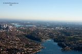
This one took me a while to figure out, in part because it is over 3 minutes after the last shot in this gallery. The shots in between are basically valueless garbage, but show us swinging back around to the north over Sydney Harbour.
Thus we find ourselves over the previously mentioned Middle Harbour, the branch of Sydney Harbour that extends beyond the Spit Bridge. The helicopter must have been continuing north while I shot this from the left-hand side looking west.
The office buildings on the left of the frame would be North Sydney. The stretch of water beyond that is the Parramatta River which comes from the west into Sydney Harbour. The flat bridge on the left of frame is the Iron Cove Bridge, which crosses an inlet (called Iron Cove, unsurprisingly) which runs off the Parramatta River. If you keep moving your eye to the right, you'll encounter an island in the middle of the river.
That's Cockatoo Island, an island which was once around 12.9 ha (32 acres), but has been extended to about 18 ha. It was heavily timbered sandstone before the arrival of Europeans, after which it was converted to a penal establishment. Of course, Sydney itself was a penal establishment so it was a prison within a prison for convicts who had reoffended. The convicts didn't just sit around, but created dry docks, which were in turn used for a shipyard which operated from 1857 to 1991. It was an important facility for the Royal Australian Navy.
Following the flow of the Parramatta River to the right of the frame you eventually see an arched bridge. That is the Gladesville Bridge, a 580 m concrete arch Road Bridge which was built between 1959 and 1964.
Now let's bring our eyes nearer and to the right again, looking at the office towers. This would be Chatswood, one of the peripheral business districts that sprang up across Sydney during the 20th century to try to take the load off the main central business district. Of course, the suburb itself dates back far further, having been established as a settlement in 1876. The name came from the wife of the then Mayor of Willoughby (the local government city which it is a part of) whose name was Charlotte or, more commonly, "Chattie". The original name of Chattie's Wood (since there were actually trees there at one time) was contracted to Chatswood.
Now let's look at the bays that are directly in front of us. The headland on the right that juts into Middle Harbour is Hallstrom Point, named after Sir Edward Hallstrom. A lot of place names in Sydney, especially in the inner part, stemmed from people who lived and died in the 19th century. That is not the case here. Hallstrom was born in the 19th century (1886) but lived most of his life in the 20th century before dying in 1970. He had an interest in refrigeration and produced a kerosene powered absorption refrigerator in 1923. It was designed primarily for use in the Australian outback (where Hallstrom had been born), and I recall having seen some still in use as late as the 1970s. He later produced other gas and electric powered models in a factory in Willoughby, adding munitions to the factory's production during World War II. The refrigerators were extremely successful and made Hallstrom a millionaire. He had a love of animals and donated large sums to Taronga Park Zoo, which is also located on Sydney Harbour, but obviously not in this shot. He also engaged in extensive philanthropy of other types. However there was some controversy with his involvement with Taronga Zoo since he was not a zoologist and was not inclined to take their advice in funding new enclosures. In any case, the location of his former home retains his name.
The point jutting out from the top (west) roughly in the centre of frame is Folly Point, in the suburb of Cammeray which is in the City of North Sydney local government area. I haven't been able to determine a definitive origin of the point's name, but apparently during both the depression of the 1890s and the Great Depression it was the site of a shanty town. That was very different to now; the suburb is now home to the (very) well-heeled. The lowest priced two-bedroom unit that I could find was $1.39 million. For an apartment. An apartment. Anyway, looking to the right of Folly Point you can see a jetty sticking out. This is the home of Cammeray Shipwrights, and Cammeray Marina. The park at the end of the bay is Tunks Park, which was named after William Tunks, the first Mayor of St Leonards from 1867 to 1883. (After 1883 it became part of North Sydney.)
The bay that runs off to the left from Folly Point ends at Primrose Park and Willoughby Creek, though neither are particularly visible here.
© 2000-2023 AKMC. May not be used, copied or reproduced without written permission.