


|
|
|
|
|
|
| |
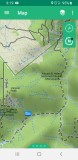
Where it says MSH Monument top rt. that is cathedral falls, just one slant log after the falls. After Tumwater there are many spots with logs down a couple of root wads and tread work that needs doing . The flag is at aprox 3.6 miles in and looks like a big storm just flattened the trees. My guess is 100 from Tumwater junction and the mess. We did'nt go further, to hard and dangerous to navigate
Sherri 6-19-20
All images are copyrighted. Use in any form without permission is prohibited
| comment | |